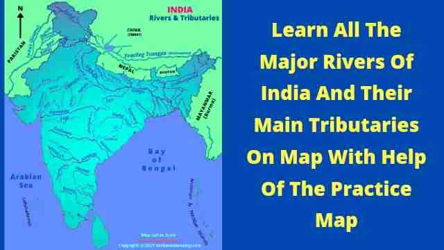
If you want to know about the major rivers of India and their tributaries, the map of rivers in India can be more useful for you. Rivers of India map can make your learning easy. River maps are also important for research and development. 


There are numerous rivers flowing on the Indian Subcontinent but some major rivers and their tributaries play vital roles in various sectors. Being more useful, many major cities have developed on river banks as well as many multipurpose river valleys have also developed on the river.


Map of major rivers of India and their main tributaries is also important for various exam perspectives. Hence you should have to know mostly from the general awareness and exams perspective.


Rivers In India on map

What are the rivers?

River Definition: Rivers are the bodies of natural water that flows according to the land slope in a certain direction. Rivers mostly originate from the highlands like mountains and plateaus. Waters in the rivers are mainly supplied by the Rain and Ice.


On the other hand, we can say, "When water bodies naturally and continually flow in a certain direction they are called the river".


Map Of Rivers In India And Their Tributaries


The rivers of India map is showing all major rivers and their main tributaries which can help you to know about the Indian rivers.


Map Of Rivers In India

List Of Rivers In India, Origins Place And Tributaries 


Rivers Name

Origin Place

Tributaries


Ganga River

(2510km)


Gangotri Glacier (Uttarakhand)

Yamuna, Gomati, Ghagra, Son, Gandak, Ramganga, Bagmati, Damodar

Yamuna River

(1385km)

Yamunotri Glacier (Uttarakhand)

Chambal, Sindh, Ken, Betva


Chambal River

(965km)

Vindhyan Mountain Range

Kali Sindh, Parbati, Banas

Indus (Sindhu) River

(2880km, 1114km in India)


Mansarovar Lake

Shyonk, Gilgit, Khelam, Chenab, Ravi, Sutlej

Satluj River

(1050km)

Rakshastal Lake 

Spiti, Vayas

Chenab

(1180km, 574km in India)

Lahaul and Spiti (Himachal Pradesh)

Thirot, Sohal, Liddrari


Brahmaputra

(2580km, 916km in India)


Mansarovar Lake

Subansiri, Tista, Manas, Dibang, Lohit, Dhansiri


Godavari River

(1465km)

Western Ghats (Nasik Dist. Maharashtra)

Penganga, Wainganga, Indrawati, Sabari, Manjira


Krishna River

(1400km)

Near Mahabaleshwar

Koyana, Panchganga, Dudhganga, Malprabha, Bhima, Musi


Kaveri River

(760km)

Brahmagiri Mountain (Kurg Dist.)

Hemavati, Amravati, Noil


Mahanadi

(858km)

Amarkantak (Singha range)

Hansdev, Tel, eeb

Narmada River

(1312km)

Amarkantak

Hiran, Barna, Tava, Dudhi

Tapti River

(724km)

Baitul ( MP)

Purna, Kshipra, Mor

Periyar

(244km)

Sivagiri hill

Western ghat

Mullayar, Cheruthani

Son

(780km)

Amarkantak Plateau

Rihand, Kunhar

Penner River

(597km)

Nandidurga mountain

Papadhani, Chitravati


Top Ten Longest Rivers In India List


S.N

Rivers

Length

1.

The Ganga

2510km

2.

The Godavari

1465km

3.

The Krishna

1400km

4.

The Yamuna

1385km

5.

The Narmada

1312km

6.

The Indus

1114km

7.

The Brahmaputra

916km

8.

The Mahanadi

858km

9.

The Son

780km

10.

The Kaveri

760km


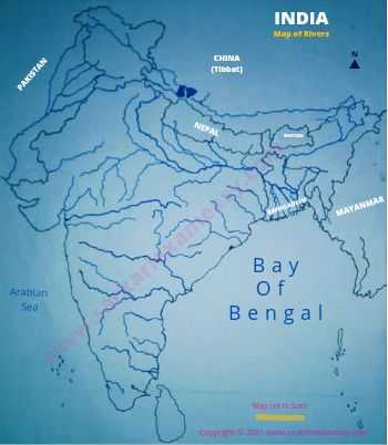
Blank Map Of Rivers In India For Practice


The main tributaries of major rivers are frequently asked in the examinations, So download this blank rivers map to practice regularly.


Blank Map Of Rivers In India

Download Practice Map


If you are preparing for the competitive exams or want to know about the major rivers of India with the help of the map, this map of rivers in India is able to fulfil your needs in a single map. 

Post a Comment

Previous Post Next Post